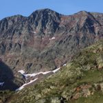
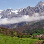

Pica d’Estats: A 7 day hike around Catalonia’s holy mountain
How to get there? The hike starts at Arinsal, in Andorra. The easiest way to get there from Barcelona is to take the bus to Seu d’Urgel. Here switch busses to Viella (Andorra), and in Viella take the bus to Arinsal.
Difficulty: The equivalent of 4km/h on level ground is an average mountain hiking speed of 300 m of climbing an hour with a 15 kg rucksack on your back. There should be no problems for a trained hiker, as long as the weather stays good and the path is free of snow (from end of June or first half of July, or even later). This itinerary is a beautiful short trek along easy-to-find paths. Alternative trails along forgotten tracks and passes are certainly wilder, lonelier and more adventurous, but you need a guide.
Maps: Pica d’Estats (Editorial Alpina) or Pica d’Estats – Aneto (Institut Cartografic de Catalunya)
Day 1 : from Arinsal (1466 m) to Refuge J.M. Montfort (4 ½ hours)
0.00 The red/white well-marked GR 11 leaves Arinsal 50m above the Prats Sobirans Residence. It’s a broad path heading NW (left hand side), easy but quite steep.
1.00 Aigues Juntes. Cross the torrents and continue to follow the GR 11 marks following the Coma Pedrosa (Pedrosa valley) up to the pass.
2.05 Coma Pedrosa Pass. A path to the left leaves our path to go to the Coma Perdrosa Refuge, Andorra’s only guarded refuge. Continue on the GR 11. The scenery becomes wilder now as it crosses a large pla and goes up steep to the N to reach
3.20 Estany Negre ( the black pond, 2629 m). The path stays near to the pond, but in June and early July, when there’s still snow, it is best to leave the path as you could easily glide into the cold pond and never get out again (!). Head NNE until
3.45 Port de Baiau ( 2757 m). This is the Spanish border and a steep stony descent to the hut you can see from here now.
4.15 Estany de Baiau. The last metres are very steep and it takes at least 15 minutes to get to the hut.
4.30 Refugi J.M. Monfort (Baiau, 2517m). A free metallic Federacio d’ Entitats Excursionsistas de Catalunya hut with 9 sleeping places for a total of 18 persons (2 per bench). If crowded FEEC members have priority rights. If it’s too crowded best to camp near the lake.
Day 2 : from Baiau to Estany d’Estats (6 ¼ hours)
You may prefer to leave as early as possible (dawn if you sleep in the hut). Hiking under the Spanish sun can be tough.
0.00 Refugi de Baiau (J.M. Monfort, 2517 m). Just continue to follow the red /white marked GR 11 as it takes you along some beautiful pounds (Estanys d’Ascorbes) trough the
1.00 Pla de Baiau, (2211 m). Now cross the torrent, follow the marked GR 11 trail further down and cross
1.15 Pla d’Arcalis, and just follow the red /white GR 11 to
2.10 Pla the Boet, (1860 m) Here we leave the GR 11 to go to the Refuge de Vall Ferrara to have a drink, sandwich or (good!) salad. The guard speaks English well.
2.35 Refugi de Vall Ferrara , (1940 m). The unmarked path climbs steeply N to the
3.25 Cap d’Areste (head of Areste), (2045 m) where it turns W contouring the Serrat d’Areste – quite level with plenty of wild flowers – up to
4.00 Baranc de Sotlo (Sotlo torent), (2000 m). Cross it to find nice place to rest under the last trees near the trail. From here on you can see the Pica d’Estats in front of you. The path is very clear and goes up in 3 stages along some beautiful warm cascades due to the heating up of the slow-flowing water. Take a bath if you like.
4.30 Pleta de Sotlo, (2150 m). First stage : a marshy large pla collecting waters coming from some 12 ponds and lakes. The path keeps to the left of the meadow to head steeply up to
5.10 Estany the Sotlo, (2352 m) Second stage : a large lake known for its chamois (this is a wildlife protected area). You could camp here but if you intend to climb the peak d’Estats next day it is preferable to camp at
6.15 Estany d’Estats, (2471 m.) Third stage. Seek out some beautiful places to set up your tent higher up, not to far from the many torrents enjoying the scenery and observing chamois. Near the lake it’s quite damp at night.
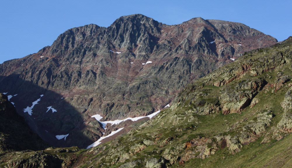
Day 3 : Climbing the Pica d’Estats (3144 m) (7 ¼ hours to Baborte hut)
If the weather is hot it it a good idea to leave early to avoid the heat and (around 15th of August) the incredible number of Catalans that want to climb “their” peak. If you do not wish to stay for a second night at the lake, head to the Baborte hut.
0.00 Estany d’Estats, 2471 m the path is evident and climbs steeply up to
1.24 port de Sotlo (the Sotlo pass, 2894 m). Here you can either take the hiker’s route that crosses the pass for an incursion into the French Ariege, or opt for the more difficult climbing route that sticks almost exactly to the border. This alternative needs some basic knowledge of climbing and ropes. The normal hiking path goes S down to
1.45 Cometa d’Estats ( 2786 m) where it turns to the right (W). In early summer there’s often a lot of snow here and simple crampons may be useful. There’s a spring halfway, where the path goes up steeply and joins a yellow marked path coming from France. Follow it up to
2.15 Collade de Riufred (cold river pass, 2978 m.). For a beautiful view on the Pica d’Estats and the French Ariege you could climb the Montcalm (3077 m), the Pica d’Estats French twin at your left hand’s side. To the right the path continues to the the Pica.
2.44 Pic Verdaquer (3125 m) . There’s a memorial tablet here dedicated to the catalan poet Verdaquer and another with a touching poem written by friends of a boy scout who died here. From Pic Verdaquer its only a few very steep metres down and up to
2.54 La Pica d’Estats (3143 m). When the weather is clear there’s a magnificent 360° panorama here. To the West you can distinguish the Certascans hut, Romedo Lakes, Mont Roig and many others up to the Maladeta massif.
On the peak itself several memorial tablets, and of course the Catalan flag, commemorating important dates of the Catalan combat for sovereignty. There’s also an Occitan flag – once both sides of the Pyrenees were one country, speaking an almost identical language, Occitan and Catalan.
Back the way you came.
5.30 Estany d’Estats (2471 m). Siesta and further down to Estany Sotlo (2352 m), where the baranc de Sotlo (Sotlo torrent) cuts the path, about half way round the lake. Take the smaller trail that follows the torrent up to the right (W) until you reach
6.15 Circ de Sotlo (2470 m). A chamois area – if you’re not to noisy you may see dozens of them. The cairned trail turns SW steep up to
6.45 Col de Baborte (2618 m). A cairned path drops down to a suspended valley with some beautiful wild ponds. Now the path splits (both are ok) and continues to the
7.20 Circ de Baborte (2440 m) and the unguarded Baborte hut. It’s a free FEEC hut, metallic as the Baiau hut, but orange, 8 benches (16 persons). FEEC members have priority rights. If the hut is full camp in the circ or beside the beautiful Estany Baborte further down (2360 m).
Day 4 : From Baborte to Planel de Boavi (Cabaña de la Borda)
0.00 Circ de Baborte (2440 m). The cairned path heads to Coll de Sellente (2585 m), highest point of today’s hike. Here steeply 250 m down through a wild high valley to the
1.30 ruins of the Sellente hut (2330 m), bombed by fascists during civil war. From here on the path gets broader (there was an old mule path to the hut) and in broad serpentine brings you down to the
2.10 Planell de Santa Pau, ruins of an older shepherds summer stay huts and cortals, (2133 m). Just follow the path further down, at the lower end of the Plannell. It crosses the Riu de Sellente (Sellente river) and continues winding down. After jumping over the river again the path becomes part of the river for some 30 m. Further down is a junction with the cami de Broate (Broate path) coming down from the Broate hut. Nearby is a beautiful cascade, the Broate fall. The path we follow turns to the left.
3.25 Riu de Sellente (1700 m). The bridge doesn’t exist anymore. You’ll have to wade through the river. The mule path takes us down through a wild forest with plenty of mushrooms (in September) to another bridge that doesn’t exist anymore.
4.30 Planell de Boavi (1460 m). There is no need to cross the river here. A sometimes vague path takes through meadows and bushes alongside the river. In September this is a place to pick mushrooms. You could camp somewhere here or follow the path up to
4.35 Borda de Boavi. A stone bridge crosses the river and follows the stony track for some 50 m. There take the path going up to the meadow and the cabaña de la Borda (1440 m).
Day 5 : from Borda de Boavi to lake Romedo d’Alt + rest day (3 hours)
0.00 Cabaña de la Borda de Boavi (1440 m). There’s a steep red marked path, old and not always very clear, starting NW of the hut. It brings you through the woods along the wild Riu de Certascans to the next higher shepherd’s hut, Cabaña de Lluri (1650 m). The path goes on up to the
1.40 Pista de Romedo (1960 m). Follow this track to the right, it’s an easy walk almost level and straight to the lower Romedo lake
2.25 Estany Romedo de Baix (2020 m). You see an iron gate to a tunnel in front of you. The footpath to the higher Romedo lake starts left of the gate. Indeed, you have to climb a few meters. Once the climbing is done, an easy-to-follow path brings you through the wetlands along riu Romedo to
2.55 Estany Romedo d’Alt (2132 m), one of Catalonia’s most beautiful mountain lakes. There are a few very nice places to set up your tent for the night and take a rest before starting your “lake tour” (there are 9 lakes).
Lake tour around Serrat de Seno (4 hours)
From Romedo d’Alt (2132 m) a cairned trail right hand side (E) of the lake takes you to Estany de Seno (only some 20 m higher), and further steep track up to Estany Golax (2200 m) turns to the E to cross a pass from where you can see Estany Aguiló d’Alt (2247 m). A cairned sheep’s trail goes down the Estany Aguiló de Baix (2204 m), further down to the Laguna d’Aguiló (2050 m), following the Aguiló river down to lake Romedo the Baix ( 2020 m) and coming up along the path you already know back to Romedo d’Alt (2132 m). Nice views !
Day 6 : from Romedo Lake to Estany de Flamicella
0.00 Romedo d’Alt (2132 m). Take the path left of the lake. It takes you up to the collada de Lluri, turning to the left down to the pista de Romedo. Some hundred metres down before reaching the track the path crosses the red marked path coming up towards the Certascans hut. Follow that red marked trail up to the right.
1.15 Refugi de Certascans (2240 m). Alessandro, the Catalan guard, is a warm person but doesn’t speak English (he does speak Spanish and French). He has drinks, good salads and sandwiches. The cairned path goes up NW to the lake – one of the biggest mountain lakes of the Pyrenees – then turns W to head for the pass
2.45 Coll de Certascans (2680 m). The trail goes W down the valley following the torrents curve to the SW.
3.25 Estanay Blau de Gueroso (2470 m). Follow the cairned some 200 m further down to where it splits, take the right going W down to a pond and two ruined shepherds huts near the Gueroso river.
4.00 pond . Cross the river somewhere. The trail heads up to the Collade de Flamicella, to the pass you see (NWW) between the Torre del Gueroso peak and Cap de Causes. Once through the pass enjoy the lovely Flamicella Lake.
4.45 Estany de Flamicella (2280 m, trouts) . There’s plenty of wood here, half wild horses and chamois. A charming place to camp for your last night in the wild.
Day 7 : Estany de Flamicella to Tavascan
0.00 Estany de Flamicella (2280 m). The path down to Tavascan starts at the lake overflow at the S and follows the mountain’s bend down to a marshy meadow with a ruined shepherd’s hut.
0.48 Gueroso river (2040 m). Continue following the path next to the river down to
2.20 bordes de Noarre (1600m) and from here further down to Grauss.
3.40 Grauss, Road to Tavascan (1190 m). At bordes del Grau, where the road turns, take the old mule path, a nicer way to enter
4.25 Tavascan (1100 m). Hotels, phone, taxi